
Topografische kaart Quandary Peak
Interactieve kaart
Klik op de kaart om de hoogte weer te geven.
Over deze kaart
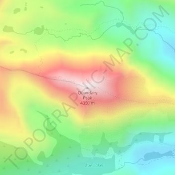
Naam: Topografische kaart Quandary Peak, hoogte, reliëf.
Gemiddelde hoogte: 3.833 m
Minimale hoogte: 3.466 m
Maximale hoogte: 4.343 m
Quandary Peak is the highest summit of the Tenmile Range in the Rocky Mountains of North America and is the most commonly climbed fourteener in Colorado. It has nearly the same elevation as Castle Peak and Mount Evans. It lies in Summit County and within the White River National Forest about 6 miles (10 km) south-southwest of the town of Breckenridge.
Andere topografische kaarten
Klik op een kaart om zijn topografie, zijn hoogte en zijn reliëf te bekijken.
Crested Butte
United States of America > Colorado > Crested Butte
Crested Butte, Gunnison County, Colorado, 81224, United States of America
Gemiddelde hoogte: 2.798 m
Dream Lake
United States of America > Colorado
Dream Lake, Flat Top Mountain Trail, Larimer County, Colorado, United States of America
Gemiddelde hoogte: 3.150 m
Dolores County
United States of America > Colorado
Dolores County, Colorado, United States of America
Gemiddelde hoogte: 2.385 m
Wild Horse
United States of America > Colorado > Wild Horse
Wild Horse, Pueblo County, Colorado, United States of America
Gemiddelde hoogte: 1.496 m
Centennial
United States of America > Colorado > Centennial
Centennial, Arapahoe County, Colorado, United States of America
Gemiddelde hoogte: 1.722 m
Rio Grande County
United States of America > Colorado
Rio Grande County, Colorado, United States of America
Gemiddelde hoogte: 2.771 m
Rio Blanco County
United States of America > Colorado
Rio Blanco County, Colorado, United States of America
Gemiddelde hoogte: 2.161 m
Idaho Springs
United States of America > Colorado > Idaho Springs
Idaho Springs, Clear Creek County, Colorado, United States of America
Gemiddelde hoogte: 2.684 m
White Hills
United States of America > Colorado
White Hills, Custer County, Colorado, 81252, United States of America
Gemiddelde hoogte: 2.447 m
Mount Arthur
United States of America > Colorado
Mount Arthur, El Paso County, Colorado, United States of America
Gemiddelde hoogte: 3.002 m
Telluride
United States of America > Colorado > Telluride
Telluride, San Miguel County, Colorado, United States of America
Gemiddelde hoogte: 3.125 m
Alamosa County
United States of America > Colorado
Alamosa County, Colorado, United States of America
Gemiddelde hoogte: 2.359 m
Golden
United States of America > Colorado > Golden
Golden, Jefferson County, Colorado, United States of America
Gemiddelde hoogte: 1.940 m