
Topografische kaart New Strawn
Interactieve kaart
Klik op de kaart om de hoogte weer te geven.
Over deze kaart
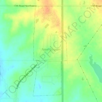
Naam: Topografische kaart New Strawn, hoogte, reliëf.
Locatie: New Strawn, Coffey County, Kansas, United States (38.25014 -95.74807 38.27398 -95.73648)
Gemiddelde hoogte: 336 m
Minimale hoogte: 320 m
Maximale hoogte: 355 m
Andere topografische kaarten
Klik op een kaart om zijn topografie, zijn hoogte en zijn reliëf te bekijken.
Gridley
United States > Kansas > Coffey County
Gridley, Coffey County, Kansas, United States
Gemiddelde hoogte: 350 m
Lebo
United States > Kansas > Coffey County
Lebo, Coffey County, Kansas, United States
Gemiddelde hoogte: 351 m
Waverly
United States > Kansas > Coffey County
Waverly, Coffey County, Kansas, United States
Gemiddelde hoogte: 344 m
Burlington
United States > Kansas > Coffey County
Burlington, Coffey County, Kansas, United States
Gemiddelde hoogte: 315 m
LeRoy
United States > Kansas > Coffey County
LeRoy, Coffey County, Kansas, 66857, United States
Gemiddelde hoogte: 306 m