
Topografische kaart Eminence
Interactieve kaart
Klik op de kaart om de hoogte weer te geven.
Eminence
According to the United States Census Bureau, the city of Eminence has a total area of 2.9 square miles (7.4 km2), of which 0.04 square miles (0.1 km2), or 1.70%, is water. The city is located on high ground, with elevations up to 960 feet (290 m), where several watersheds converge. The source of the Little Kentucky River, a tributary of the Kentucky River, is just west of Eminence, while Town Creek to the north and Drennon Creek to the east also rise in Eminence and flow north to the Kentucky River. Fox Run rises in the southern part of Eminence and flows south via Bullskin Creek and Brashears Creek to the Salt River. The Kentucky and the Salt River are both tributaries of the Ohio River.
Over deze kaart
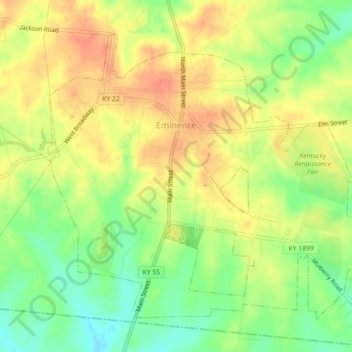
Naam: Topografische kaart Eminence, hoogte, reliëf.
Locatie: Eminence, Henry County, Kentucky, 40019, United States (38.35079 -85.19681 38.37916 -85.15221)
Gemiddelde hoogte: 274 m
Minimale hoogte: 249 m
Maximale hoogte: 293 m
Andere topografische kaarten
Klik op een kaart om zijn topografie, zijn hoogte en zijn reliëf te bekijken.