
Topografische kaart Carrickfergus
Interactieve kaart
Klik op de kaart om de hoogte weer te geven.
Over deze kaart
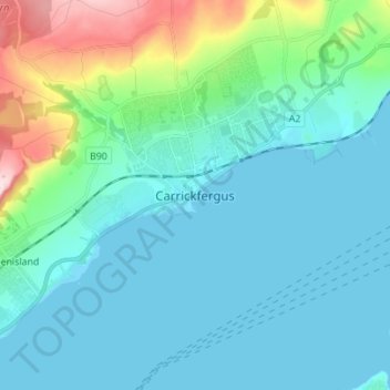
Naam: Topografische kaart Carrickfergus, hoogte, reliëf.
Gemiddelde hoogte: 49 m
Minimale hoogte: 0 m
Maximale hoogte: 281 m
Andere topografische kaarten
Klik op een kaart om zijn topografie, zijn hoogte en zijn reliëf te bekijken.
Ahoghill
United Kingdom > Northern Ireland > County Antrim
Ahoghill, County Antrim, Ulster, Northern Ireland, BT42 1JZ, United Kingdom
Gemiddelde hoogte: 84 m
Portrush
United Kingdom > Northern Ireland > County Antrim
Portrush, County Antrim, Ulster, Northern Ireland, BT56 8BN, United Kingdom
Gemiddelde hoogte: 23 m
Ballymena
United Kingdom > Northern Ireland > County Antrim
Ballymena, County Antrim, Northern Ireland, BT43 6DT, United Kingdom
Gemiddelde hoogte: 74 m
Larne
United Kingdom > Northern Ireland > County Antrim
Larne, County Antrim, Northern Ireland, BT40 1JS, United Kingdom
Gemiddelde hoogte: 54 m
Belfast
United Kingdom > Northern Ireland > County Antrim
Belfast, County Antrim, Ulster, Northern Ireland, BT1 5GS, United Kingdom
Gemiddelde hoogte: 87 m
Antrim
United Kingdom > Northern Ireland > County Antrim
Antrim, County Antrim, Northern Ireland, BT41 4AR, United Kingdom
Gemiddelde hoogte: 50 m