
Topografische kaart Victoria Peak
Interactieve kaart
Klik op de kaart om de hoogte weer te geven.
Over deze kaart
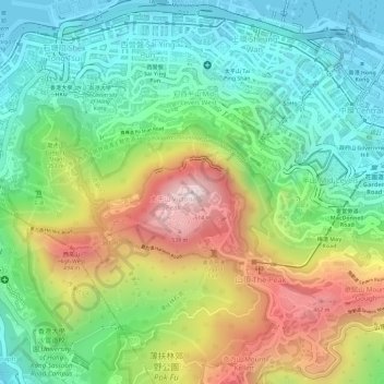
Naam: Topografische kaart Victoria Peak, hoogte, reliëf.
Locatie: Victoria Peak, Hong Kong Island, Hong Kong, China (22.27599 114.14541 22.27609 114.14551)
Gemiddelde hoogte: 209 m
Minimale hoogte: -2 m
Maximale hoogte: 534 m
Victoria Peak is a hill on the western half of Hong Kong Island. It is also known as Mount Austin, and locally as The Peak only generally. With an elevation of 552 metres (1,811 ft), it is the tallest hill on Hong Kong Island, and the 29th tallest in the territory of Hong Kong. It is a major tourist attraction offering views of Central, Victoria Harbour, Lamma Island and the surrounding islands.
Andere topografische kaarten
Klik op een kaart om zijn topografie, zijn hoogte en zijn reliëf te bekijken.
Braemar Hill
China > Hong Kong > Hong Kong Island
Braemar Hill, Hong Kong Island, Hong Kong, 000000, China
Gemiddelde hoogte: 89 m
Pok Fu Lam Reservoir
China > Hong Kong > Hong Kong Island
Pok Fu Lam Reservoir, Telegraph Bay, Pok Fu Lam, Southern District, Hong Kong Island, Hong Kong, China
Gemiddelde hoogte: 192 m
Tai Tam Mound Waterfall
China > Hong Kong > Hong Kong Island
Tai Tam Mound Waterfall, Southern District, Hong Kong Island, Hong Kong, China
Gemiddelde hoogte: 150 m
Wong Chuk Hang San Wai
China > Hong Kong > Hong Kong Island > Wong Chuk Hang San Wai
Wong Chuk Hang San Wai, Southern District, Hong Kong Island, Hong Kong, China
Gemiddelde hoogte: 116 m
Sai Wan
China > Hong Kong > Hong Kong Island
Sai Wan, Central and Western District, Hong Kong Island, Hong Kong, China
Gemiddelde hoogte: 81 m
Southern District
China > Hong Kong > Hong Kong Island
Southern District, Hong Kong Island, Hong Kong, China
Gemiddelde hoogte: 36 m
Victoria Park
China > Hong Kong > Hong Kong Island
Victoria Park, Causeway Bay, Wan Chai District, Hong Kong Island, Hong Kong, China
Gemiddelde hoogte: 64 m