
Topografische kaart Orofino
Interactieve kaart
Klik op de kaart om de hoogte weer te geven.
Over deze kaart
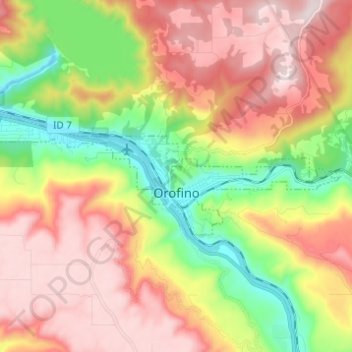
Naam: Topografische kaart Orofino, hoogte, reliëf.
Locatie: Orofino, Clearwater County, Idaho, 83544, United States (46.47097 -116.32122 46.49939 -116.19855)
Gemiddelde hoogte: 633 m
Minimale hoogte: 293 m
Maximale hoogte: 964 m
The city has a climate typical of low-elevation areas in Idaho and eastern Washington. Orofino has a dry-summer continental climate (Köppen Dsb). Due to the warm summers, it nearly qualifies as a continental Mediterranean climate (Dsa). Idaho’s all-time highest temperature of 118 °F or 47.8 °C was recorded at Orofino on July 28, 1934.
Andere topografische kaarten
Klik op een kaart om zijn topografie, zijn hoogte en zijn reliëf te bekijken.
Clearwater County
United States > Idaho > Clearwater County
Clearwater County, Idaho, United States
Gemiddelde hoogte: 1.250 m
Platinum Lake
United States > Idaho > Clearwater County
Platinum Lake, Clearwater County, Idaho, United States
Gemiddelde hoogte: 1.723 m