
Topografische kaart Georgeville
Interactieve kaart
Klik op de kaart om de hoogte weer te geven.
Over deze kaart
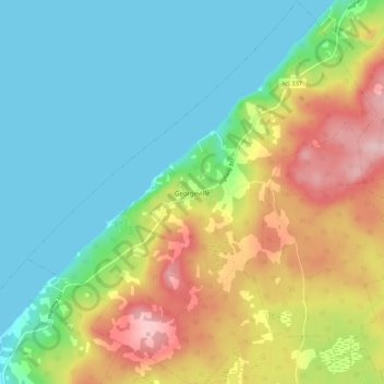
Naam: Topografische kaart Georgeville, hoogte, reliëf.
Gemiddelde hoogte: 66 m
Minimale hoogte: -1 m
Maximale hoogte: 188 m
Andere topografische kaarten
Klik op een kaart om zijn topografie, zijn hoogte en zijn reliëf te bekijken.
Loch Katrine
Canada > Nouvelle-Écosse > Municipality of the County of Antigonish
Loch Katrine, Municipality of the County of Antigonish, Antigonish County, Nouvelle-Écosse, Canada
Gemiddelde hoogte: 126 m
Tracadie
Canada > Nouvelle-Écosse > Municipality of the County of Antigonish
Tracadie, Municipality of the County of Antigonish, Antigonish County, Nouvelle-Écosse, Canada
Gemiddelde hoogte: 17 m