Topografische kaart Murat-sur-Vèbre
Interactieve kaart
Klik op de kaart om de hoogte weer te geven.
Over deze kaart
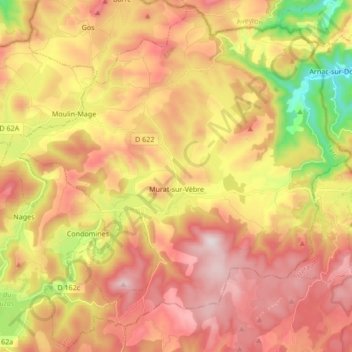
Naam: Topografische kaart Murat-sur-Vèbre, hoogte, reliëf.
Gemiddelde hoogte: 908 m
Minimale hoogte: 537 m
Maximale hoogte: 1.201 m

Klik op de kaart om de hoogte weer te geven.
Naam: Topografische kaart Murat-sur-Vèbre, hoogte, reliëf.
Gemiddelde hoogte: 908 m
Minimale hoogte: 537 m
Maximale hoogte: 1.201 m