
Topografische kaart Montamy
Interactieve kaart
Klik op de kaart om de hoogte weer te geven.
Over deze kaart
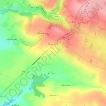
Naam: Topografische kaart Montamy, hoogte, reliëf.
Gemiddelde hoogte: 233 m
Minimale hoogte: 149 m
Maximale hoogte: 306 m
Le toponyme est attesté sous la forme Montamis au XIVe siècle. Issu de l'ancien français mont ayant le sens actuel, il est lié à la topographie du lieu, Amy étant un patronyme.