
Topografische kaart Hayborough
Interactieve kaart
Klik op de kaart om de hoogte weer te geven.
Over deze kaart
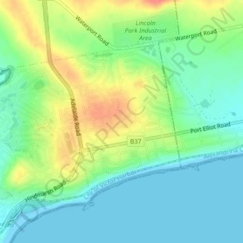
Naam: Topografische kaart Hayborough, hoogte, reliëf.
Gemiddelde hoogte: 23 m
Minimale hoogte: 0 m
Maximale hoogte: 64 m
Andere topografische kaarten
Klik op een kaart om zijn topografie, zijn hoogte en zijn reliëf te bekijken.
Fleurieu Peninsula
Australia > South Australia > City of Victor Harbor
Fleurieu Peninsula, City of Victor Harbor, South Australia, Australia
Gemiddelde hoogte: 98 m
McCracken
Australia > South Australia > City of Victor Harbor
McCracken, City of Victor Harbor, South Australia, 5211, Australia
Gemiddelde hoogte: 25 m
Granite Island
Australia > South Australia > City of Victor Harbor
Granite Island, City of Victor Harbor, South Australia, Australia
Gemiddelde hoogte: 1 m
Victor Harbor
Australia > South Australia > City of Victor Harbor
Victor Harbor, City of Victor Harbor, South Australia, 5211, Australia
Gemiddelde hoogte: 20 m
Lower Inman Valley
Australia > South Australia > City of Victor Harbor
Lower Inman Valley, City of Victor Harbor, South Australia, 5211, Australia
Gemiddelde hoogte: 99 m
Hindmarsh Tiers
Australia > South Australia > City of Victor Harbor
Hindmarsh Tiers, City of Victor Harbor, South Australia, 5202, Australia
Gemiddelde hoogte: 297 m
Unnamed (No.HA1336) Heritage Agreement
Australia > South Australia > City of Victor Harbor > Inman Valley > Hindmarsh Valley
Unnamed (No.HA1336) Heritage Agreement, Strangways Road, Hindmarsh Valley, Inman Valley, City of Victor Harbor, South Australia, 5211, Australia
Gemiddelde hoogte: 248 m
Hindmarsh Valley
Australia > South Australia > City of Victor Harbor
Hindmarsh Valley, City of Victor Harbor, South Australia, 5211, Australia
Gemiddelde hoogte: 167 m