
Topografische kaart Adilabad
Interactieve kaart
Klik op de kaart om de hoogte weer te geven.
Over deze kaart
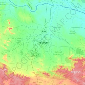
Naam: Topografische kaart Adilabad, hoogte, reliëf.
Gemiddelde hoogte: 310 m
Minimale hoogte: 196 m
Maximale hoogte: 626 m
Adilabad has an average elevation of 264 metres. The district shares its boundaries with Nirmal and Karimnagar districts of Telangana to the south, Komaram Bheem district on the east, with Nanded on the west and Yavatmal and Chandrapur districts of Maharashtra to the north.