
Topografische kaart Village of Walden
Interactieve kaart
Klik op de kaart om de hoogte weer te geven.
Village of Walden
The Wallkill passes through a small gorge between the two dams and loses approximately 60 feet (18 m) of elevation in the process. The surrounding topography in the village is, correspondingly, gentle rolling hills of this section of the Great Appalachian Valley between the higher rises of the Shawangunk Ridge, visible to the west from some sections of the village, and the Hudson Highlands to the southwest. The highest elevation is roughly 520 feet (158 m) above sea level along Overlook Road at the village's western boundary; the lowest is 260 feet (79 m) along the Wallkill at the northern village line.
Over deze kaart
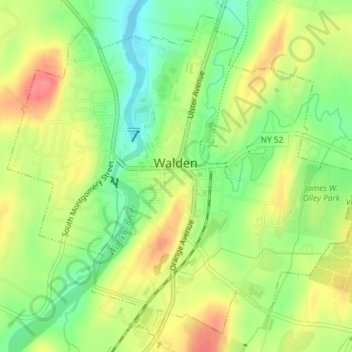
Naam: Topografische kaart Village of Walden, hoogte, reliëf.
Gemiddelde hoogte: 114 m
Minimale hoogte: 80 m
Maximale hoogte: 149 m