
Topografische kaart Bir
Interactieve kaart
Klik op de kaart om de hoogte weer te geven.
Over deze kaart
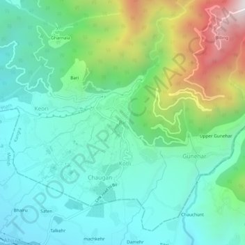
Naam: Topografische kaart Bir, hoogte, reliëf.
Locatie: Bir, Baijnath, Kangra, Himachal Pradesh, 176077, India (32.02452 76.70551 32.06452 76.74551)
Gemiddelde hoogte: 1.628 m
Minimale hoogte: 1.284 m
Maximale hoogte: 2.560 m
The paragliding launch site is in the meadow at Billing (14 km north of Bir), at an elevation of 2400 meters, while the landing site and most tourist accommodations are in the village of Chowgan (also spelled Chaugan), on the southern edge of Bir.
Andere topografische kaarten
Klik op een kaart om zijn topografie, zijn hoogte en zijn reliëf te bekijken.
Deol
India > Himachal Pradesh > Baijnath
Deol, Baijnath, Kangra, Himachal Pradesh, India
Gemiddelde hoogte: 1.496 m
Utrala
India > Himachal Pradesh > Baijnath
Utrala, Baijnath, Kangra, Himachal Pradesh, India
Gemiddelde hoogte: 1.517 m
Sansal
India > Himachal Pradesh > Baijnath
Sansal, Baijnath, Kangra, Himachal Pradesh, 176077, India
Gemiddelde hoogte: 1.490 m
Billing
India > Himachal Pradesh > Baijnath
Billing, Baijnath, Kangra, Himachal Pradesh, 176077, India
Gemiddelde hoogte: 2.114 m