
Topografische kaart Sawyer County
Interactieve kaart
Klik op de kaart om de hoogte weer te geven.
Over deze kaart
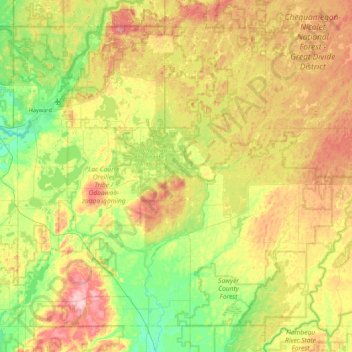
Naam: Topografische kaart Sawyer County, hoogte, reliëf.
Locatie: Sawyer County, Wisconsin, USA (45.63776 -91.55181 46.15791 -90.67697)
Gemiddelde hoogte: 420 m
Minimale hoogte: 340 m
Maximale hoogte: 552 m
Andere topografische kaarten
Klik op een kaart om zijn topografie, zijn hoogte en zijn reliëf te bekijken.
Brookfield
USA > Wisconsin > Brookfield
Brookfield, Waukesha County, Wisconsin, USA
Gemiddelde hoogte: 251 m
Sturgeon Bay
USA > Wisconsin > Sturgeon Bay
Sturgeon Bay, Door County, Wisconsin, 54235, USA
Gemiddelde hoogte: 199 m
Scandinavia
USA > Wisconsin > Scandinavia
Scandinavia, Waupaca County, Wisconsin, USA
Gemiddelde hoogte: 293 m
Rubicon River
Rubicon River, Hartford, Washington County, Wisconsin, 53027, USA
Gemiddelde hoogte: 312 m
New Richmond
USA > Wisconsin > New Richmond
New Richmond, Saint Croix County, Wisconsin, 54017-1733, USA
Gemiddelde hoogte: 304 m
Robbins Island
Robbins Island, Town of Florence, Florence County, Wisconsin, 52121, USA
Gemiddelde hoogte: 385 m
Pine River
Pine River, Town of Long Lake, Florence County, Wisconsin, 54121, USA
Gemiddelde hoogte: 460 m
Johnson Creek
Johnson Creek, Town of Stockbridge, Calumet County, Wisconsin, 53088, USA
Gemiddelde hoogte: 278 m
Avoca Lake
Avoca Lake, West Lakeshore Drive, Avoca, Iowa County, Wisconsin, 53506, USA
Gemiddelde hoogte: 212 m
Two Rivers
USA > Wisconsin > Two Rivers
Two Rivers, Manitowoc County, Wisconsin, USA
Gemiddelde hoogte: 180 m