
Topografische kaart Morgantown
Interactieve kaart
Klik op de kaart om de hoogte weer te geven.
Over deze kaart
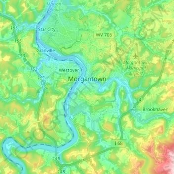
Naam: Topografische kaart Morgantown, hoogte, reliëf.
Locatie: Morgantown, Monongalia County, West Virginia, United States (39.57431 -79.98816 39.67510 -79.89877)
Gemiddelde hoogte: 337 m
Minimale hoogte: 241 m
Maximale hoogte: 581 m
During the 1970s, the U.S. Department of Transportation built an experimental driverless personal rapid transit system in the city, citing the area's variable seasonal climate and geographic elevations as factors in testing the technology's viability. The Morgantown Personal Rapid Transit (PRT) has been in use since 1975. University students use the system for free travel between the campuses.
Andere topografische kaarten
Klik op een kaart om zijn topografie, zijn hoogte en zijn reliëf te bekijken.
Harmony Grove
United States > West Virginia > Monongalia County
Harmony Grove, Monongalia County, West Virginia, 26501, United States
Gemiddelde hoogte: 326 m
Mylan Park
United States > West Virginia > Monongalia County
Mylan Park, Monongalia County, West Virginia, United States
Gemiddelde hoogte: 359 m
Daybrook
United States > West Virginia > Monongalia County > Daybrook
Daybrook, Monongalia County, West Virginia, 26521, United States
Gemiddelde hoogte: 375 m