
Topografische kaart Dasmarinas
Interactieve kaart
Klik op de kaart om de hoogte weer te geven.
Over deze kaart
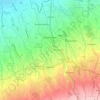
Naam: Topografische kaart Dasmarinas, hoogte, reliëf.
Locatie: Dasmarinas, Cavite, Calabarzon, 4114, Philippines (14.25680 120.92045 14.36930 121.00849)
Gemiddelde hoogte: 114 m
Minimale hoogte: 26 m
Maximale hoogte: 246 m
Dasmariñas is partly lowland and partly hill. The Poblacion itself is elevated. From an elevation of 80 meters at the Poblacion, the land rises to 250 meters towards Silang. Generally, land near rivers and creeks are rugged. Dasmariñas is outside the typhoon belt and has no fault line constraints. Further, it is served by natural drainage system since it is traversed by several rivers and water tributaries draining to the Manila Bay. The city has yet to experience floods.