
Topografische kaart Bellingham
Interactieve kaart
Klik op de kaart om de hoogte weer te geven.
Bellingham
According to the United States Census Bureau, the town has a total area of 19.0 square miles (49.2 km2), of which 18.5 square miles (47.9 km2) is land and 0.5 square mile (1.3 km2) (2.58%) is water. The town's mean elevation is 293 feet (89 m) above sea level.
Over deze kaart
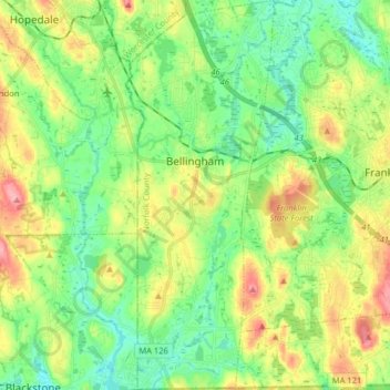
Naam: Topografische kaart Bellingham, hoogte, reliëf.
Gemiddelde hoogte: 84 m
Minimale hoogte: 45 m
Maximale hoogte: 153 m
Andere topografische kaarten
Klik op een kaart om zijn topografie, zijn hoogte en zijn reliëf te bekijken.
Lake Massapoag
United States > Massachusetts > Norfolk County > Sharon
Because of the lake and the fact that Sharon is at a slightly higher elevation than the surrounding towns, and because it is located on the main rail line going south from Boston, the shores of the lake developed into a minor summer resort with several large hotels, summer camps and cottage colonies. Temple…
Gemiddelde hoogte: 84 m
Wellesley Farms
United States > Massachusetts > Norfolk County > Wellesley > Wellesley Farms
Gemiddelde hoogte: 48 m