
Topografische kaart Albany
Interactieve kaart
Klik op de kaart om de hoogte weer te geven.
Over deze kaart
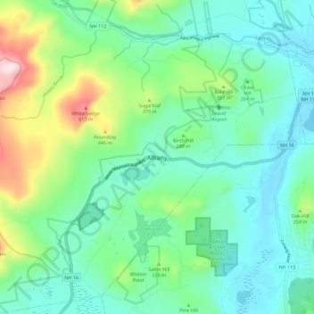
Naam: Topografische kaart Albany, hoogte, reliëf.
Locatie: Albany, Carroll County, New Hampshire, United States (43.91998 -71.23296 43.99998 -71.15296)
Gemiddelde hoogte: 276 m
Minimale hoogte: 136 m
Maximale hoogte: 709 m
According to the United States Census Bureau, the town has a total area of 75.8 square miles (196.2 km2), of which 75.1 square miles (194.6 km2) are land and 0.58 square miles (1.5 km2) are water, comprising 0.79% of the town. It is drained by the Swift River in the north and the Chocorua River in the south. The town lies fully within the Saco River watershed. Mount Chocorua, the highest point in Albany, has an elevation of 3,474 feet (1,059 m), and Mount Paugus has an elevation of 3,201 ft (976 m).
Andere topografische kaarten
Klik op een kaart om zijn topografie, zijn hoogte en zijn reliëf te bekijken.
Whitton Pond
United States > New Hampshire > Carroll County > Albany
Whitton Pond, Albany, Carroll County, New Hampshire, United States
Gemiddelde hoogte: 273 m
Albany
United States > New Hampshire > Carroll County > Albany
Albany, Carroll County, New Hampshire, 03818, United States
Gemiddelde hoogte: 409 m