
Topografische kaart South Bristol
Interactieve kaart
Klik op de kaart om de hoogte weer te geven.
Over deze kaart
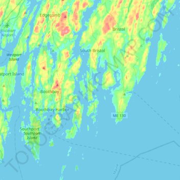
Naam: Topografische kaart South Bristol, hoogte, reliëf.
Locatie: South Bristol, Lincoln County, Maine, United States (43.75991 -69.58489 43.99526 -69.50580)
Gemiddelde hoogte: 13 m
Minimale hoogte: -3 m
Maximale hoogte: 96 m
Andere topografische kaarten
Klik op een kaart om zijn topografie, zijn hoogte en zijn reliëf te bekijken.
Westport Island
United States > Maine > Lincoln County > Westport Island
Westport Island, Lincoln County, Maine, United States
Gemiddelde hoogte: 21 m
Trevett
United States > Maine > Lincoln County > Boothbay
Trevett, Boothbay, Lincoln County, Maine, 04571, United States
Gemiddelde hoogte: 13 m
Monhegan Island Plantation
United States > Maine > Lincoln County
Monhegan Island Plantation, Lincoln County, Maine, 04852, United States
Gemiddelde hoogte: 0 m
Boothbay
United States > Maine > Lincoln County
Boothbay, Lincoln County, Maine, United States
Gemiddelde hoogte: 9 m
Nobleboro
United States > Maine > Lincoln County
Nobleboro, Lincoln County, Maine, 04555, United States
Gemiddelde hoogte: 40 m
Waldoboro
United States > Maine > Lincoln County
Waldoboro, Lincoln County, Maine, 04572, United States
Gemiddelde hoogte: 40 m