
Topografische kaart Mountain River
Interactieve kaart
Klik op de kaart om de hoogte weer te geven.
Over deze kaart
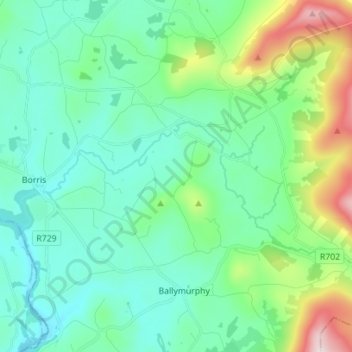
Naam: Topografische kaart Mountain River, hoogte, reliëf.
Gemiddelde hoogte: 136 m
Minimale hoogte: 11 m
Maximale hoogte: 576 m
Andere topografische kaarten
Klik op een kaart om zijn topografie, zijn hoogte en zijn reliëf te bekijken.
Castlemore
Castlemore, Tullowbeg ED, The Municipal District of Tullow, County Carlow, Leinster, Ireland
Gemiddelde hoogte: 78 m
Fennagh
Fennagh, Ballyknockan, Fennagh ED, The Municipal District of Muinebeag, County Carlow, Leinster, Ireland
Gemiddelde hoogte: 96 m
Derreen
Derreen, Butlersgrange, Tullow Rural ED, The Municipal District of Tullow, County Carlow, Leinster, Ireland
Gemiddelde hoogte: 95 m
Bagenalstown
Ireland > County Carlow > Bagenalstown
Bagenalstown, The Municipal District of Muinebeag, County Carlow, Leinster, R21 DR77, Ireland
Gemiddelde hoogte: 75 m
Palatine
Palatine, Killyshane, Burtonhall ED, The Municipal District of Carlow, County Carlow, Leinster, R93 Y381, Ireland
Gemiddelde hoogte: 76 m
Borris
Borris, The Municipal District of Muinebeag, County Carlow, Leinster, R95 C92R, Ireland
Gemiddelde hoogte: 60 m
Vermount
Vermount, Clonmore ED, The Municipal District of Tullow, County Carlow, Leinster, Ireland
Gemiddelde hoogte: 153 m