
Topografische kaart Union Springs
Interactieve kaart
Klik op de kaart om de hoogte weer te geven.
Over deze kaart
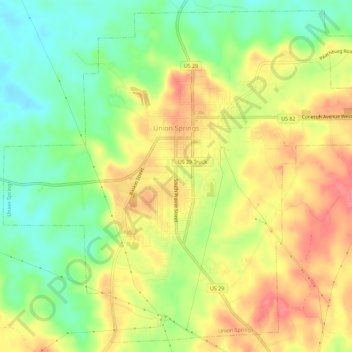
Naam: Topografische kaart Union Springs, hoogte, reliëf.
Locatie: Union Springs, Bullock County, Alabama, 36089, United States (32.11554 -85.74391 32.16076 -85.68732)
Gemiddelde hoogte: 139 m
Minimale hoogte: 102 m
Maximale hoogte: 175 m
Andere topografische kaarten
Klik op een kaart om zijn topografie, zijn hoogte en zijn reliëf te bekijken.
Scottland
United States > Alabama > Bullock County
Scottland, Bullock County, Alabama, 36059, United States
Gemiddelde hoogte: 150 m