
Topografische kaart Rutherfordton
Interactieve kaart
Klik op de kaart om de hoogte weer te geven.
Over deze kaart
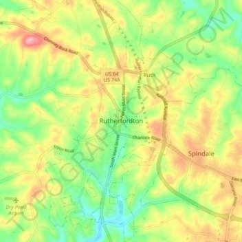
Naam: Topografische kaart Rutherfordton, hoogte, reliëf.
Gemiddelde hoogte: 302 m
Minimale hoogte: 241 m
Maximale hoogte: 375 m
Andere topografische kaarten
Klik op een kaart om zijn topografie, zijn hoogte en zijn reliëf te bekijken.
Rutherfordton
United States > North Carolina > Rutherford County > Rutherfordton
Rutherfordton, Rutherford County, North Carolina, 28139, United States
Gemiddelde hoogte: 300 m
Union Mills
United States > North Carolina > Rutherford County
Union Mills, Rutherford County, North Carolina, 28167, United States
Gemiddelde hoogte: 326 m
Lake Lure
United States > North Carolina > Rutherford County
Lake Lure, Rutherford County, North Carolina, 28746, United States
Gemiddelde hoogte: 363 m
Spindale
United States > North Carolina > Rutherford County > Spindale
Spindale, Rutherford County, North Carolina, 28160, United States
Gemiddelde hoogte: 299 m
Chimney Rock
United States > North Carolina > Rutherford County > Chimney Rock
Chimney Rock, Rutherford County, North Carolina, 28720, United States
Gemiddelde hoogte: 550 m