
Topografische kaart Poverty Point
Interactieve kaart
Klik op de kaart om de hoogte weer te geven.
Over deze kaart
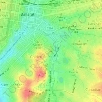
Naam: Topografische kaart Poverty Point, hoogte, reliëf.
Gemiddelde hoogte: 437 m
Minimale hoogte: 406 m
Maximale hoogte: 477 m
Andere topografische kaarten
Klik op een kaart om zijn topografie, zijn hoogte en zijn reliëf te bekijken.
Golden Point
Australia > Victoria > Ballarat
Golden Point, Ballarat, City of Ballarat, Victoria, 3350, Australia
Gemiddelde hoogte: 435 m
Brown Hill
Australia > Victoria > Ballarat
Brown Hill, Ballarat, City of Ballarat, Victoria, Australia
Gemiddelde hoogte: 474 m
Ballarat Central
Australia > Victoria > Ballarat
Ballarat Central, Ballarat, City of Ballarat, Grampians, Victoria, Australia
Gemiddelde hoogte: 443 m
Lake Wendouree
Australia > Victoria > Ballarat
Lake Wendouree, Steve Moneghetti track, Lake Wendouree, Ballarat, City of Ballarat, Grampians, Victoria, 3350, Australia
Gemiddelde hoogte: 452 m
Golden Point
Australia > Victoria > Ballarat
Golden Point, Ballarat, City of Ballarat, Grampians, Victoria, 3350, Australia
Gemiddelde hoogte: 435 m