
Topografische kaart Simi Valley
Interactieve kaart
Klik op de kaart om de hoogte weer te geven.
Over deze kaart
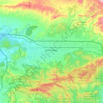
Naam: Topografische kaart Simi Valley, hoogte, reliëf.
Locatie: Simi Valley, Ventura County, California, United States (34.20842 -118.83110 34.32267 -118.63256)
Gemiddelde hoogte: 405 m
Minimale hoogte: 176 m
Maximale hoogte: 890 m
Simi Valley is a city located in the very southeast corner of Ventura County, bordering the San Fernando Valley in Los Angeles County, and is a part of the Greater Los Angeles Area. The city of Simi Valley basically consists of the eponymous valley itself. The city of Simi Valley borders the Santa Susana Mountains to the north, the Simi Hills to the east and south, and is adjacent to Thousand Oaks to the southwest and Moorpark to the west. Simi Valley is connected to the nearby San Fernando Valley by the Santa Susana Pass in the extreme east of Simi Valley. Simi Valley is located at 34°16'16" North, 118°44'22" West (34.271078, −118.739428) with an elevation of 700–1,000 ft (210–300 m) above sea level. The syncline Simi Valley is located in the western part of the region called the Transverse Ranges. The valley is surrounded by the Santa Susana Mountains to the north and Simi Hills to the east and south. While the Santa Susana Mountains separate the valley from the Los Padres National Forest in the north, the Simi Hills separate it from Conejo Valley in the south. In the extreme east is Rocky Peak, one of Santa Susana Mountains' highest peaks, which is a dividing line between Ventura County to the west and Los Angeles County to the east. On the other side of the valley, in the extreme west side of Simi Valley is Mount McCoy, which may be most known for its 12 ft. concrete cross that sits at its peak. The physiographical valley is a structural as well as a topographic depression. The Simi Valley, just as neighboring San Fernando Valley, owes its existence and shape to the faulting and folding of the rocks. It is essentially a structural valley and not wholly the work of erosion. It is drained by the Calleguas Creek and also its principal tributary, Conejo Creek. Both of these originate in the Santa Susana Mountains.
Andere topografische kaarten
Klik op een kaart om zijn topografie, zijn hoogte en zijn reliëf te bekijken.
Camarillo
United States > California > Ventura County
Camarillo, Ventura County, California, United States
Gemiddelde hoogte: 90 m
Oxnard
United States > California > Ventura County
Oxnard, Ventura County, California, United States
Gemiddelde hoogte: 16 m
Thousand Oaks
United States > California > Ventura County > Thousand Oaks
Thousand Oaks, Ventura County, California, United States
Gemiddelde hoogte: 303 m
Newbury Park
United States > California > Ventura County > Thousand Oaks
Newbury Park, Thousand Oaks, Ventura County, CAL Fire Southern Region, California, 91320, United States
Gemiddelde hoogte: 262 m
CSUCI Repeater Station
United States > California > Ventura County
CSUCI Repeater Station, Ventura County, California, 93012, United States
Gemiddelde hoogte: 50 m
Oak Park
United States > California > Ventura County
Oak Park, Ventura County, California, 91377, United States
Gemiddelde hoogte: 393 m
San Buenaventura (Ventura)
United States > California > Ventura County
San Buenaventura (Ventura), Ventura County, California, United States
Gemiddelde hoogte: 163 m
Haines
United States > California > Ventura County
Haines, Ventura County, California, 93060, United States
Gemiddelde hoogte: 89 m
Mira Monte
United States > California > Ventura County
Mira Monte, Ventura County, California, United States
Gemiddelde hoogte: 221 m
Moorpark
United States > California > Ventura County
Moorpark, Ventura County, California, 93021, United States
Gemiddelde hoogte: 219 m
Channel Islands Beach
United States > California > Ventura County
Channel Islands Beach, Ventura County, California, United States
Gemiddelde hoogte: 3 m
Montalvo
United States > California > Ventura County > Ventura
Montalvo, Ventura, Ventura County, CAL Fire Southern Region, California, 93009, United States
Gemiddelde hoogte: 42 m
Paseo del Sol
United States > California > Ventura County > Simi Valley
Paseo del Sol, Simi Valley, Ventura County, California, 90363, United States
Gemiddelde hoogte: 333 m
Thousand Oaks
United States > California > Ventura County > Thousand Oaks
Thousand Oaks, Ventura County, California, 91362, United States
Gemiddelde hoogte: 288 m
Quatal Canyon
United States > California > Ventura County
Quatal Canyon, Ventura County, CAL Fire Southern Region, California, United States
Gemiddelde hoogte: 1.286 m
Ventura
United States > California > Ventura County
Ventura, Ventura County, California, United States
Gemiddelde hoogte: 120 m
Santa Paula
United States > California > Ventura County
Santa Paula, Ventura County, CAL Fire Southern Region, California, United States
Gemiddelde hoogte: 148 m
Fillmore
United States > California > Ventura County
Fillmore, Ventura County, CAL Fire Contract Counties, California, 93016, United States
Gemiddelde hoogte: 193 m
Kenney Grove Park
United States > California > Ventura County
Kenney Grove Park, Ventura County, CAL Fire Southern Region, California, 93016, United States
Gemiddelde hoogte: 192 m
Thousand Oaks
United States > California > Ventura County
Thousand Oaks, Ventura County, California, United States
Gemiddelde hoogte: 333 m
Whiteface
United States > California > Ventura County
Whiteface, Ventura County, CAL Fire Southern Region, California, 90363, United States
Gemiddelde hoogte: 517 m
Ojai
United States > California > Ventura County
Ojai, Ventura County, CAL Fire Southern Region, California, 93023, United States
Gemiddelde hoogte: 289 m
Point Mugu State Park
United States > California > Ventura County
Point Mugu State Park, Ventura County, CAL Fire Southern Region, California, United States
Gemiddelde hoogte: 158 m
Junipero Serra Park
United States > California > Ventura County > Ventura
Junipero Serra Park, Ventura, Ventura County, CAL Fire Southern Region, California, United States
Gemiddelde hoogte: 49 m
Greenwich Village
United States > California > Ventura County > Thousand Oaks
Greenwich Village, Thousand Oaks, Ventura County, CAL Fire Southern Region, California, 91360, United States
Gemiddelde hoogte: 275 m
Oak Park
United States > California > Ventura County
Oak Park, Ventura County, California, 91377, United States
Gemiddelde hoogte: 378 m
Buckhorn
United States > California > Ventura County
Buckhorn, Ventura County, California, United States
Gemiddelde hoogte: 223 m
San Buenaventura (Ventura)
United States > California > Ventura County
San Buenaventura (Ventura), Ventura County, CAL Fire Southern Region, California, United States
Gemiddelde hoogte: 158 m
Westlake Village
United States > California > Ventura County > Thousand Oaks
Westlake Village, Thousand Oaks, Ventura County, CAL Fire Southern Region, California, 91361, United States
Gemiddelde hoogte: 305 m
Hollywood Beach
United States > California > Ventura County
Hollywood Beach, Ventura County, CAL Fire Southern Region, California, 93035, United States
Gemiddelde hoogte: 3 m
Matilija
United States > California > Ventura County > Ojai
Matilija, Ojai, Ventura County, CAL Fire Southern Region, California, 93023, United States
Gemiddelde hoogte: 241 m
Ventu Park
United States > California > Ventura County > Thousand Oaks > Newbury Park
Ventu Park, Newbury Park, Thousand Oaks, Ventura County, CAL Fire Southern Region, California, 91320, United States
Gemiddelde hoogte: 250 m
Oxnard
United States > California > Ventura County > Oxnard
Oxnard, Ventura County, California, 93031, United States
Gemiddelde hoogte: 69 m
Virginia Colony
United States > California > Ventura County > Moorpark
Virginia Colony, Moorpark, Ventura County, CAL Fire Southern Region, California, 93021, United States
Gemiddelde hoogte: 219 m
La Conchita
United States > California > Ventura County
La Conchita, Ventura County, CAL Fire Southern Region, California, United States
Gemiddelde hoogte: 121 m
Fairview
United States > California > Ventura County
Fairview, Ventura County, CAL Fire Southern Region, California, United States
Gemiddelde hoogte: 280 m
Castlewood at Big Sky
United States > California > Ventura County > Simi Valley > Castlewood at Big Sky
Castlewood at Big Sky, Simi Valley, Ventura County, California, 93065-6278, United States
Gemiddelde hoogte: 360 m
Casitas Springs
United States > California > Ventura County > Ventura > Casitas Springs
Casitas Springs, Ventura, Ventura County, California, 93022, United States
Gemiddelde hoogte: 182 m
Lake Piru
United States > California > Ventura County
Lake Piru, Ventura County, CAL Fire Southern Region, California, United States
Gemiddelde hoogte: 375 m
Fillmore
United States > California > Ventura County
Fillmore, Ventura County, California, 93016, United States
Gemiddelde hoogte: 181 m
Saticoy
United States > California > Ventura County > Saticoy
Saticoy, Ventura County, California, 93004, United States
Gemiddelde hoogte: 55 m
Oak View
United States > California > Ventura County
Oak View, Ventura County, California, 93022, United States
Gemiddelde hoogte: 184 m
San Nicolas Island
United States > California > Ventura County
San Nicolas Island, Ventura County, CAL Fire Southern Region, California, United States
Gemiddelde hoogte: 38 m
Port Hueneme
United States > California > Ventura County
Port Hueneme, Ventura County, California, United States
Gemiddelde hoogte: 7 m
Mount Pinos
United States > California > Ventura County
Mount Pinos, Ventura County, California, 93222, United States
Gemiddelde hoogte: 2.468 m