
Topografische kaart Maxwell
Interactieve kaart
Klik op de kaart om de hoogte weer te geven.
Over deze kaart
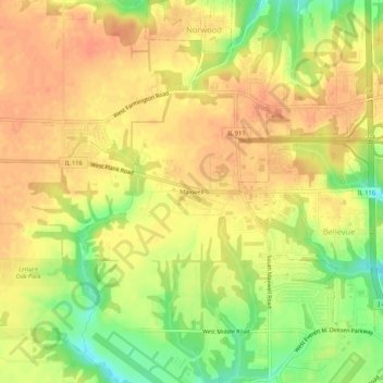
Naam: Topografische kaart Maxwell, hoogte, reliëf.
Locatie: Maxwell, Peoria County, Illinois, United States (40.66865 -89.72038 40.70865 -89.68038)
Gemiddelde hoogte: 207 m
Minimale hoogte: 177 m
Maximale hoogte: 222 m
Andere topografische kaarten
Klik op een kaart om zijn topografie, zijn hoogte en zijn reliëf te bekijken.
Peoria
United States > Illinois > Peoria County
Peoria, Peoria County, Illinois, United States
Gemiddelde hoogte: 189 m
Kickapoo
United States > Illinois > Peoria County
Kickapoo, Peoria County, Illinois, 61528, United States
Gemiddelde hoogte: 198 m
Chillicothe
United States > Illinois > Peoria County
Chillicothe, Peoria County, Illinois, 61523, United States
Gemiddelde hoogte: 146 m
Dunlap
United States > Illinois > Peoria County
Dunlap, Peoria County, Illinois, United States
Gemiddelde hoogte: 212 m
Bartonville
United States > Illinois > Peoria County
Bartonville, Peoria County, Illinois, 61607, United States
Gemiddelde hoogte: 165 m
West Peoria
United States > Illinois > Peoria County > West Peoria
West Peoria, Peoria County, Illinois, 61604, United States
Gemiddelde hoogte: 174 m
Princeville
United States > Illinois > Peoria County
Princeville, Peoria County, Illinois, United States
Gemiddelde hoogte: 220 m
Norwood
United States > Illinois > Peoria County
Norwood, Peoria County, Illinois, United States
Gemiddelde hoogte: 200 m
Peoria
United States > Illinois > Peoria County > Peoria
Peoria, Peoria County, Illinois, 61602-6199, United States
Gemiddelde hoogte: 196 m
Brimfield
United States > Illinois > Peoria County
Brimfield, Peoria County, Illinois, United States
Gemiddelde hoogte: 213 m