
Topografische kaart Pinedale
Interactieve kaart
Klik op de kaart om de hoogte weer te geven.
Pinedale
Pinedale is a previously unincorporated community in Fresno County, California. It lies at an elevation of 348 feet (106 m). It was once a rural community located on the Southern Pacific Railroad 3.5 miles (5.6 km) north-northwest of Clovis but has since become surrounded and annexed by the city of Fresno. Millerton Lake State Recreational Area is to its NE. The ZIP Code is 93650, and the community is inside area code 559.
Over deze kaart
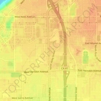
Naam: Topografische kaart Pinedale, hoogte, reliëf.
Gemiddelde hoogte: 107 m
Minimale hoogte: 78 m
Maximale hoogte: 114 m
Andere topografische kaarten
Klik op een kaart om zijn topografie, zijn hoogte en zijn reliëf te bekijken.