
Topografische kaart Washburn
Interactieve kaart
Klik op de kaart om de hoogte weer te geven.
Over deze kaart
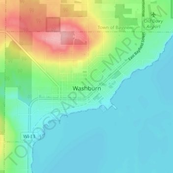
Naam: Topografische kaart Washburn, hoogte, reliëf.
Locatie: Washburn, Bayfield County, Wisconsin, United States (46.65932 -90.92621 46.68801 -90.86069)
Gemiddelde hoogte: 213 m
Minimale hoogte: 178 m
Maximale hoogte: 308 m
Andere topografische kaarten
Klik op een kaart om zijn topografie, zijn hoogte en zijn reliëf te bekijken.
Grand View
United States > Wisconsin > Bayfield County
Grand View, Town of Grandview, Bayfield County, Wisconsin, 54839, United States
Gemiddelde hoogte: 314 m
Barksdale
United States > Wisconsin > Bayfield County
Barksdale, Town of Barksdale, Bayfield County, Wisconsin, 54806, United States
Gemiddelde hoogte: 197 m
Drummond
United States > Wisconsin > Bayfield County
Drummond, Town of Drummond, Bayfield County, Wisconsin, United States
Gemiddelde hoogte: 402 m
Cornucopia
United States > Wisconsin > Bayfield County
Cornucopia, Town of Bell, Bayfield County, Wisconsin, 54827, United States
Gemiddelde hoogte: 212 m
Lund Lake
United States > Wisconsin > Bayfield County
Lund Lake, Town of Drummond, Bayfield County, Wisconsin, United States
Gemiddelde hoogte: 367 m
Port Wing
United States > Wisconsin > Bayfield County
Port Wing, Town of Port Wing, Bayfield County, Wisconsin, 54865, United States
Gemiddelde hoogte: 204 m
Stewart Lake
United States > Wisconsin > Bayfield County
Stewart Lake, Town of Drummond, Bayfield County, Wisconsin, United States
Gemiddelde hoogte: 443 m
Sioux River
United States > Wisconsin > Bayfield County
Sioux River, Town of Washburn, Bayfield County, Wisconsin, United States
Gemiddelde hoogte: 267 m
Mason
United States > Wisconsin > Bayfield County
Mason, Bayfield County, Wisconsin, United States
Gemiddelde hoogte: 293 m
Devils Lake
United States > Wisconsin > Bayfield County
Devils Lake, Town of Barnes, Bayfield County, Wisconsin, United States
Gemiddelde hoogte: 361 m
Bullhead Lake
United States > Wisconsin > Bayfield County
Bullhead Lake, Town of Grandview, Bayfield County, Wisconsin, United States
Gemiddelde hoogte: 451 m
Boreal Forest
United States > Wisconsin > Bayfield County
Boreal Forest, Town of Port Wing, Bayfield County, Wisconsin, 54865, United States
Gemiddelde hoogte: 185 m
Town of Washburn
United States > Wisconsin > Bayfield County
Town of Washburn, Bayfield County, Wisconsin, United States
Gemiddelde hoogte: 332 m
Town of Bayfield
United States > Wisconsin > Bayfield County
Town of Bayfield, Bayfield County, Wisconsin, 54814, United States
Gemiddelde hoogte: 244 m
Delta
United States > Wisconsin > Bayfield County
Delta, Town of Delta, Bayfield County, Wisconsin, United States
Gemiddelde hoogte: 335 m
Bayfield
United States > Wisconsin > Bayfield County
Bayfield, Bayfield County, Wisconsin, United States
Gemiddelde hoogte: 245 m
Town of Orienta
United States > Wisconsin > Bayfield County
Town of Orienta, Bayfield County, Wisconsin, United States
Gemiddelde hoogte: 227 m
Town of Clover
United States > Wisconsin > Bayfield County
Town of Clover, Bayfield County, Wisconsin, 54844, United States
Gemiddelde hoogte: 274 m
Herbster
United States > Wisconsin > Bayfield County
Herbster, Town of Clover, Bayfield County, Wisconsin, 54844, United States
Gemiddelde hoogte: 196 m
Cable
United States > Wisconsin > Bayfield County
Cable, Town of Cable, Bayfield County, Wisconsin, United States
Gemiddelde hoogte: 418 m
Iron River
United States > Wisconsin > Bayfield County
Iron River, Town of Oulu, Bayfield County, Wisconsin, United States
Gemiddelde hoogte: 289 m