
Doe een donatie
Rust jezelf uit voor je volgende avontuur:
Als Amazon-partner verdient deze site een commissie op in aanmerking komende aankopen, zonder extra kosten voor jou.
Topografische kaart Burnaby
Klik op de kaart om de hoogte weer te geven.
Doe een donatie
Rust jezelf uit voor je volgende avontuur:
Als Amazon-partner verdient deze site een commissie op in aanmerking komende aankopen, zonder extra kosten voor jou.
Burnaby
Burnaby occupies 98.60 square kilometres (38.07 sq mi) and is located at the geographic centre of the Metro Vancouver area and home to the Metro Vancouver regional government in Metrotown. Situated between the city of Vancouver on the west and Port Moody, Coquitlam, and New Westminster on the east, Burnaby is bounded by Burrard Inlet and the Fraser River on the north and south, respectively. Burnaby, Vancouver and New Westminster collectively occupy the major portion of the Burrard Peninsula. The elevation of Burnaby ranges from sea level to a maximum of 370 metres (1,210 ft) atop Burnaby Mountain. Due to its elevation, the city of Burnaby typically has quite a bit more snowfall during the winter months than nearby Vancouver or Richmond. Overall, the physical landscape of Burnaby is one of hills, ridges, valleys and an alluvial plain. The land features and their relative locations have had an influence on the location, type and form of development in the city.
Doe een donatie
Rust jezelf uit voor je volgende avontuur:
Als Amazon-partner verdient deze site een commissie op in aanmerking komende aankopen, zonder extra kosten voor jou.
Over deze kaart
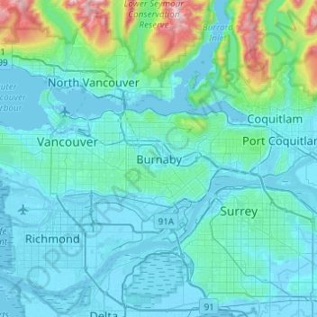
Naam: Topografische kaart Burnaby, hoogte, reliëf.
Gemiddelde hoogte: 144 m
Minimale hoogte: -4 m
Maximale hoogte: 1.429 m
Doe een donatie
Rust jezelf uit voor je volgende avontuur:
Als Amazon-partner verdient deze site een commissie op in aanmerking komende aankopen, zonder extra kosten voor jou.
Andere topografische kaarten
Klik op een kaart om zijn topografie, zijn hoogte en zijn reliëf te bekijken.
Deer Lake Park
Canada > British Columbia > Metro Vancouver Regional District > Burnaby
Gemiddelde hoogte: 64 m
Burnaby Lake
Canada > British Columbia > Metro Vancouver Regional District > Burnaby
Gemiddelde hoogte: 32 m
Central Park
Canada > British Columbia > Metro Vancouver Regional District > Burnaby
Gemiddelde hoogte: 113 m
Brentwood
Canada > British Columbia > Metro Vancouver Regional District > Burnaby
Gemiddelde hoogte: 69 m
Doe een donatie
Rust jezelf uit voor je volgende avontuur:
Als Amazon-partner verdient deze site een commissie op in aanmerking komende aankopen, zonder extra kosten voor jou.
Barnet Marine Park
Canada > British Columbia > Metro Vancouver Regional District > Burnaby
Gemiddelde hoogte: 95 m
Stride Hill
Canada > British Columbia > Metro Vancouver Regional District > Burnaby
Gemiddelde hoogte: 68 m
Riverway Sports Complex
Canada > British Columbia > Metro Vancouver Regional District > Burnaby
Gemiddelde hoogte: 42 m
Maywood
Canada > British Columbia > Metro Vancouver Regional District > Burnaby
Gemiddelde hoogte: 113 m
Doe een donatie
Rust jezelf uit voor je volgende avontuur:
Als Amazon-partner verdient deze site een commissie op in aanmerking komende aankopen, zonder extra kosten voor jou.
Deer Lake
Canada > British Columbia > Metro Vancouver Regional District > Burnaby
Gemiddelde hoogte: 60 m
Burnaby Lake Regional Park
Canada > British Columbia > Metro Vancouver Regional District > Burnaby
Gemiddelde hoogte: 51 m
Government Road
Canada > British Columbia > Metro Vancouver Regional District > Burnaby
Gemiddelde hoogte: 45 m
Stoney Creek Park
Canada > British Columbia > Metro Vancouver Regional District > Burnaby
Gemiddelde hoogte: 85 m
Doe een donatie
Rust jezelf uit voor je volgende avontuur:
Als Amazon-partner verdient deze site een commissie op in aanmerking komende aankopen, zonder extra kosten voor jou.