
Topografische kaart Grad Požega
Interactieve kaart
Klik op de kaart om de hoogte weer te geven.
Over deze kaart
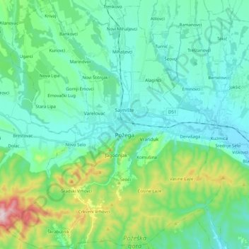
Naam: Topografische kaart Grad Požega, hoogte, reliëf.
Locatie: Grad Požega, Požega-Slavonia County, 34000, Croatia (45.26777 17.56777 45.40587 17.75298)
Gemiddelde hoogte: 222 m
Minimale hoogte: 127 m
Maximale hoogte: 595 m
Požega (elevation: 152 m (499 ft)) is located in the south-western part of the Valley of Požega, or Požega basin, in Croatian: Požeška kotlina. This fertile valley has been important since the antiquity - its Roman name was Vallis Aurea, meaning "golden valley".
Andere topografische kaarten
Klik op een kaart om zijn topografie, zijn hoogte en zijn reliëf te bekijken.
Općina Kaptol
Croatia > Požega-Slavonia County
Općina Kaptol, Požega-Slavonia County, 34334, Croatia
Gemiddelde hoogte: 349 m