
Topografische kaart Lincang
Interactieve kaart
Klik op de kaart om de hoogte weer te geven.
Lincang
Lincang covers latitude 23° 05′-25° 02′ N and longitude 98° 40′-100° 33′ E, thus straddling the Tropic of Cancer in the southern part of its administrative area, or prefecture. It is situated on the middle to lower reaches of the Mekong, known as the Lancang in China, and the Salween, or the Nu. Bordering prefectures are Pu'er to the southeast, and Baoshan and Dali to the northwest. It also borders Burma's Shan State. Elevations within the prefecture range from 450 to 3,504 metres (1,476 to 11,496 ft).
Over deze kaart
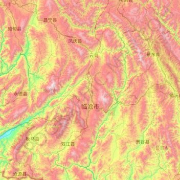
Naam: Topografische kaart Lincang, hoogte, reliëf.
Locatie: Lincang, Yunnan, China (23.07996 98.67345 25.03572 100.54641)
Gemiddelde hoogte: 1.647 m
Minimale hoogte: 479 m
Maximale hoogte: 3.464 m
Andere topografische kaarten
Klik op een kaart om zijn topografie, zijn hoogte en zijn reliëf te bekijken.
Napahai Nature Reserve
China > Yunnan > Shangri-La > Jiantang > Chui Zongdala
Gemiddelde hoogte: 3.410 m
Baihetan Dam
China > Yunnan > Qiaojia County > Zhaotong City > Dazhai
The Baihetan Dam (simplified Chinese: 白鹤滩大坝; traditional Chinese: 白鶴灘大壩; pinyin: Báihètān Dàbà) is a large hydroelectric dam on the Jinsha River, an upper stretch of the Yangtze River in Sichuan and Yunnan provinces, in southwest China. The dam is a 289-meter-tall double-curvature arch…
Gemiddelde hoogte: 1.061 m
Yuanyang
China > Yunnan > Yuanyang County
It covers an area of 2,200 km2 (850 sq mi) and has a population of approximately 365,000 (2002), of which 88% belong to ethnic minorities and 95% is associated with agriculture. The majority of the inhabitants of the county are from the Hani ethnic group. The GDP of Yuanyang county in 2021 was 9,312 million…
Gemiddelde hoogte: 1.171 m
Zhenyuan
China > Yunnan > Zhenyuan Yi, Hani and Lahu Autonomous County > Enle
Gemiddelde hoogte: 1.563 m
Pu'er
Pu'er is located in southern/southwestern Yunnan, on the lower reaches of the Mekong (known in Chinese as the Lancang), with the bordering prefectures being Yuxi to the northeast, Honghe to the east, Xishuangbanna to the south, Lincang to the northwest, and Dali and Chuxiong. It also shares borders with…
Gemiddelde hoogte: 1.401 m