
Topografische kaart Council Grove Lake
Interactieve kaart
Klik op de kaart om de hoogte weer te geven.
Over deze kaart
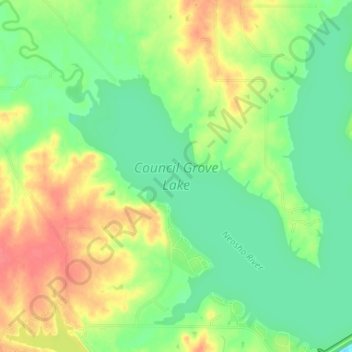
Naam: Topografische kaart Council Grove Lake, hoogte, reliëf.
Locatie: Council Grove Lake, Morris County, Kansas, United States (38.67793 -96.55655 38.72904 -96.49285)
Gemiddelde hoogte: 400 m
Minimale hoogte: 376 m
Maximale hoogte: 432 m
Andere topografische kaarten
Klik op een kaart om zijn topografie, zijn hoogte en zijn reliëf te bekijken.
White City
United States > Kansas > Morris County
White City, Morris County, Kansas, United States
Gemiddelde hoogte: 444 m
Dwight
United States > Kansas > Morris County
Dwight, Morris County, Kansas, 66849, United States
Gemiddelde hoogte: 457 m
Parkerville
United States > Kansas > Morris County
Parkerville, Morris County, Kansas, United States
Gemiddelde hoogte: 422 m
Council Grove
United States > Kansas > Morris County > Council Grove
Council Grove, Morris County, Kansas, United States
Gemiddelde hoogte: 389 m
Wilsey
United States > Kansas > Morris County
Wilsey, Morris County, Kansas, United States
Gemiddelde hoogte: 459 m