
Topografische kaart Gatton
Interactieve kaart
Klik op de kaart om de hoogte weer te geven.
Over deze kaart
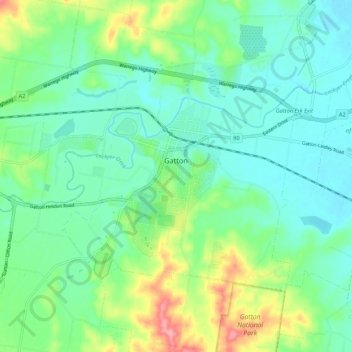
Naam: Topografische kaart Gatton, hoogte, reliëf.
Locatie: Gatton, Lockyer Valley Regional, Queensland, Australia (-27.59661 152.21943 -27.53495 152.32628)
Gemiddelde hoogte: 118 m
Minimale hoogte: 86 m
Maximale hoogte: 203 m
The area has a humid subtropical climate, with hot, humid summers and mild, sunny winters, albeit with cool nights. Heavy summer rain and warm conditions have provided ideal conditions for the areas agricultural productivity, although droughts and heatwaves can be problematic at times. Temperatures in Gatton are among the warmest in south-east Queensland in summer due to its position away from the coast but at low elevation in the Brisbane Valley.
Andere topografische kaarten
Klik op een kaart om zijn topografie, zijn hoogte en zijn reliëf te bekijken.