
Topografische kaart Caridad
Interactieve kaart
Klik op de kaart om de hoogte weer te geven.
Over deze kaart
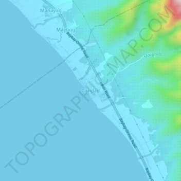
Naam: Topografische kaart Caridad, hoogte, reliëf.
Gemiddelde hoogte: 33 m
Minimale hoogte: -1 m
Maximale hoogte: 423 m
Andere topografische kaarten
Klik op een kaart om zijn topografie, zijn hoogte en zijn reliëf te bekijken.
Kantagnos
Philippines > Leyte > Baybay
Kantagnos, Baybay, 5th District, Leyte, Eastern Visayas, 6521, Philippines
Gemiddelde hoogte: 89 m
Patag
Philippines > Leyte > Baybay
Patag, Baybay, 5th District, Leyte, Eastern Visayas, 6521, Philippines
Gemiddelde hoogte: 64 m
Palhi
Philippines > Leyte > Baybay
Palhi, Baybay, 5th District, Leyte, Eastern Visayas, 6521, Philippines
Gemiddelde hoogte: 20 m
Baybay
Philippines > Leyte > Baybay
Baybay, Leyte 5th District, Leyte, Eastern Visayas, 6521, Philippines
Gemiddelde hoogte: 163 m
Lower Utod (Guadalupe)
Philippines > Leyte > Baybay
Lower Utod (Guadalupe), Baybay, Leyte 5th District, Leyte, Eastern Visayas, 6521, Philippines
Gemiddelde hoogte: 29 m
Pagbanganan River
Philippines > Leyte > Baybay > Kantagnos
Pagbanganan River, Kantagnos, Baybay, Leyte 5th District, Leyte, Eastern Visayas, 6521, Philippines
Gemiddelde hoogte: 145 m
Mount Pangasugan
Philippines > Leyte > Baybay
Mount Pangasugan, Baybay, Leyte 5th District, Leyte, Eastern Visayas, 6521, Philippines
Gemiddelde hoogte: 712 m
Mailhi
Philippines > Leyte > Baybay > Mailhi
Mailhi, Baybay, Leyte 5th District, Leyte, Eastern Visayas, 6521, Philippines
Gemiddelde hoogte: 237 m
Pangasugan River
Philippines > Leyte > Baybay
Pangasugan River, Baybay, Leyte 5th District, Leyte, Eastern Visayas, 6521, Philippines
Gemiddelde hoogte: 194 m