
Topografische kaart Los Alamos
Interactieve kaart
Klik op de kaart om de hoogte weer te geven.
Over deze kaart
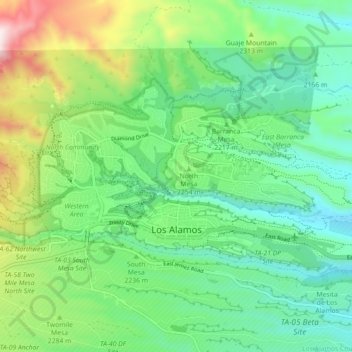
Naam: Topografische kaart Los Alamos, hoogte, reliëf.
Gemiddelde hoogte: 2.196 m
Minimale hoogte: 1.990 m
Maximale hoogte: 2.638 m
Los Alamos is located in northern New Mexico between the Rio Grande and the eastern rim of the Valles Caldera on the Pajarito Plateau, approximately 35 mi (56 km) to the northwest of Santa Fe. The elevation at the post office is 7,320 feet (2,230 m) and total land area is 11.14 square miles (28.9 km2).
Andere topografische kaarten
Klik op een kaart om zijn topografie, zijn hoogte en zijn reliëf te bekijken.
Los Alamos
United States > New Mexico > Los Alamos County > Los Alamos
Los Alamos, Los Alamos County, New Mexico, 87544, United States
Gemiddelde hoogte: 2.196 m