
Topografische kaart Haifa
Interactieve kaart
Klik op de kaart om de hoogte weer te geven.
Over deze kaart
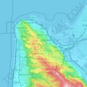
Naam: Topografische kaart Haifa, hoogte, reliëf.
Locatie: Haifa, Haifa Subdistrict, Haifa District, Israel (32.75795 34.94997 32.84270 35.07974)
Gemiddelde hoogte: 74 m
Minimale hoogte: -4 m
Maximale hoogte: 526 m
Haifa is the center of liberal Arabic-speaking culture, as it was under British colonial rule. The Arabic-speaking neighborhoods, which are mixed Muslim and Christian, are in the lowlands near the sea, while Jewish neighborhoods are at higher elevation. An active Arab cultural life has developed in the 21st century. The city is center of many Arab-owned businesses such as theaters, bars, cafes, restaurants and nightclubs which host also a different cultural discussions and art exhibitions.
Andere topografische kaarten
Klik op een kaart om zijn topografie, zijn hoogte en zijn reliëf te bekijken.
Hof HaCarmel Regional Council
Hof HaCarmel Regional Council, Hadera Subdistrict, Haifa District, 3085000, Israel
Gemiddelde hoogte: 103 m
Hadera
Hadera, Hadera Subdistrict, Haifa District, Israel
Gemiddelde hoogte: 20 m
Menashe Regional Council
Menashe Regional Council, Hadera Subdistrict, Haifa District, Israel
Gemiddelde hoogte: 85 m
Kiryat Tivon
Kiryat Tivon, Haifa Subdistrict, Haifa District, Israel
Gemiddelde hoogte: 165 m
Alona Regional Council
Alona Regional Council, Hadera Subdistrict, Haifa District, Israel
Gemiddelde hoogte: 109 m
Hadera
Israel > Haifa District > Hadera
Hadera, Hadera Subdistrict, Haifa District, 38361, Israel
Gemiddelde hoogte: 47 m
Kiryat Tivon
Kiryat Tivon, Haifa Subdistrict, Haifa District, 3608002, Israel
Gemiddelde hoogte: 95 m
Kiryat Tivon
Israel > Haifa District > Kiryat Tivon
Kiryat Tivon, Haifa District, Israel
Gemiddelde hoogte: 167 m