
Doe een donatie
Rust jezelf uit voor je volgende avontuur:
Als Amazon-partner verdient deze site een commissie op in aanmerking komende aankopen, zonder extra kosten voor jou.
Topografische kaart Boise
Klik op de kaart om de hoogte weer te geven.
Doe een donatie
Rust jezelf uit voor je volgende avontuur:
Als Amazon-partner verdient deze site een commissie op in aanmerking komende aankopen, zonder extra kosten voor jou.
Boise
Boise (locally /ˈbɔɪsi/ BOY-see) is the capital and most populous city of the U.S. state of Idaho and is the county seat of Ada County. As of the 2020 census, there were 235,684 people residing in the city. On the Boise River in southwestern Idaho, it is 41 miles (66 km) east of the Oregon border and 110 miles (177 km) north of the Nevada border. The downtown area's elevation is 2,704 feet (824 m) above sea level.
Doe een donatie
Rust jezelf uit voor je volgende avontuur:
Als Amazon-partner verdient deze site een commissie op in aanmerking komende aankopen, zonder extra kosten voor jou.
Over deze kaart
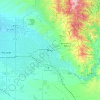
Naam: Topografische kaart Boise, hoogte, reliëf.
Locatie: Boise, Ada County, Idaho, 83701, United States (43.45662 -116.36089 43.77662 -116.04089)
Gemiddelde hoogte: 1.040 m
Minimale hoogte: 762 m
Maximale hoogte: 2.303 m
Doe een donatie
Rust jezelf uit voor je volgende avontuur:
Als Amazon-partner verdient deze site een commissie op in aanmerking komende aankopen, zonder extra kosten voor jou.
Andere topografische kaarten
Klik op een kaart om zijn topografie, zijn hoogte en zijn reliëf te bekijken.
Star
United States > Idaho > Ada County
Star is located at 43°41′39″N 116°29′25″W / 43.69417°N 116.49028°W / 43.69417; -116.49028 (43.694084, -116.490225), at an elevation of 2,470 feet (753 m) above sea level. According to the United States Census Bureau, the city has a total area of 5.86 square miles (15.18 km2), of which 5.82…
Gemiddelde hoogte: 765 m
Boise
United States > Idaho > Ada County
Boise (/ˈbɔɪziː/, BOYZ-ee; locally /ˈbɔɪsiː/ (listen), BOYSS-ee) is the capital and most populous city of the U.S. state of Idaho and is the county seat of Ada County. On the Boise River in southwestern Idaho, it is 41 miles (66 km) east of the Oregon border and 110 miles (177 km) north of the Nevada…
Gemiddelde hoogte: 970 m
Doe een donatie
Rust jezelf uit voor je volgende avontuur:
Als Amazon-partner verdient deze site een commissie op in aanmerking komende aankopen, zonder extra kosten voor jou.
Boise
United States > Idaho > Ada County
Located on the Boise River in southwestern Idaho, it is 41 miles (66 km) east of the Oregon border and 110 miles (177 km) north of the Nevada border. Downtown Boise's elevation is 2,704 feet (824 m) above sea level. Originally established as a military outpost in 1863 during the gold rush era, Boise rapidly…
Gemiddelde hoogte: 970 m
Doe een donatie
Rust jezelf uit voor je volgende avontuur:
Als Amazon-partner verdient deze site een commissie op in aanmerking komende aankopen, zonder extra kosten voor jou.
Boise
United States > Idaho > Ada County
Boise (locally /ˈbɔɪsi/ BOY-see) is the capital and most populous city of the U.S. state of Idaho. The population was 235,685 at the 2020 census. The Boise metropolitan area, also known as the Treasure Valley, includes five counties with an estimated population of 846,000, the most populous metropolitan…
Gemiddelde hoogte: 970 m
Doe een donatie
Rust jezelf uit voor je volgende avontuur:
Als Amazon-partner verdient deze site een commissie op in aanmerking komende aankopen, zonder extra kosten voor jou.
Boise
United States > Idaho > Ada County
Boise (locally /ˈbɔɪsi/ BOY-see) is the capital and most populous city of the U.S. state of Idaho. The population was 235,685 at the 2020 census. The Boise metropolitan area, also known as the Treasure Valley, includes five counties with an estimated population of 846,000, the most populous metropolitan…
Gemiddelde hoogte: 970 m
Boise
United States > Idaho > Ada County
Boise (/ˈbɔɪziː/, BOYZ-ee locally /ˈbɔɪsiː/ (listen), BOYSS-ee) is the capital and most populous city of the U.S. state of Idaho and is the county seat of Ada County. On the Boise River in southwestern Idaho, it is 41 miles (66 km) east of the Oregon border and 110 miles (177 km) north of the Nevada…
Gemiddelde hoogte: 970 m
Garden City
United States > Idaho > Ada County
Garden City is located at 43°38′44″N 116°15′58″W / 43.64556°N 116.26611°W / 43.64556; -116.26611 (43.645561, -116.266132), at an elevation of 2674 feet (815 m) above sea level.
Gemiddelde hoogte: 852 m
Doe een donatie
Rust jezelf uit voor je volgende avontuur:
Als Amazon-partner verdient deze site een commissie op in aanmerking komende aankopen, zonder extra kosten voor jou.
Star
United States > Idaho > Ada County
Star is located at 43°41′39″N 116°29′25″W / 43.69417°N 116.49028°W / 43.69417; -116.49028 (43.694084, -116.490225), at an elevation of 2,470 feet (753 m) above sea level. According to the United States Census Bureau, the city has a total area of 5.86 square miles (15.18 km2), of which 5.82…
Gemiddelde hoogte: 765 m
Doe een donatie
Rust jezelf uit voor je volgende avontuur:
Als Amazon-partner verdient deze site een commissie op in aanmerking komende aankopen, zonder extra kosten voor jou.