
Topografische kaart Fruitland
Interactieve kaart
Klik op de kaart om de hoogte weer te geven.
Over deze kaart
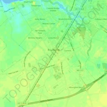
Naam: Topografische kaart Fruitland, hoogte, reliëf.
Locatie: Fruitland, Wicomico County, Maryland, 21826, United States (38.30239 -75.65086 38.33891 -75.60037)
Gemiddelde hoogte: 11 m
Minimale hoogte: -2 m
Maximale hoogte: 16 m
Andere topografische kaarten
Klik op een kaart om zijn topografie, zijn hoogte en zijn reliëf te bekijken.
Quantico
United States > Maryland > Wicomico County
Quantico, Wicomico County, Maryland, United States
Gemiddelde hoogte: 6 m
Stellas Venture
United States > Maryland > Wicomico County
Stellas Venture, Wicomico County, Maryland, United States
Gemiddelde hoogte: 19 m
Walston Switch
United States > Maryland > Wicomico County
Walston Switch, Wicomico County, Maryland, 21849, United States
Gemiddelde hoogte: 18 m
Salisbury
United States > Maryland > Wicomico County > Salisbury
Salisbury, Wicomico County, Maryland, 21803, United States
Gemiddelde hoogte: 11 m
Salisbury
United States > Maryland > Wicomico County
Salisbury, Wicomico County, Maryland, United States
Gemiddelde hoogte: 12 m
Delmar
United States > Maryland > Wicomico County
Delmar, Wicomico County, Maryland, 19940, United States
Gemiddelde hoogte: 15 m