
Topografische kaart Washington Park
Interactieve kaart
Klik op de kaart om de hoogte weer te geven.
Washington Park
Washington Park covers more than 458 acres (185 hectares) on mostly steep, wooded hillsides which range in elevation from 200 feet (61 m) at 24th & West Burnside Street to 870 feet (265 m) at SW Fairview Blvd. It comprises 241.45 acres (97.71 hectares) of city park land that has been officially designated as "Washington Park" by the City of Portland, as well as the adjacent 64-acre (26 ha) Oregon Zoo and the 153-acre (62 ha) Hoyt Arboretum, which together make up the area described as "Washington Park" on signs and maps.
Over deze kaart
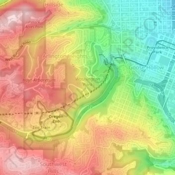
Naam: Topografische kaart Washington Park, hoogte, reliëf.
Gemiddelde hoogte: 169 m
Minimale hoogte: 15 m
Maximale hoogte: 307 m