
Topografische kaart Boring
Interactieve kaart
Klik op de kaart om de hoogte weer te geven.
Over deze kaart
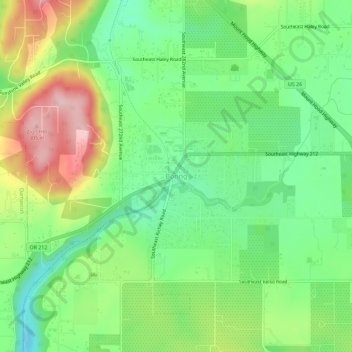
Naam: Topografische kaart Boring, hoogte, reliëf.
Gemiddelde hoogte: 183 m
Minimale hoogte: 104 m
Maximale hoogte: 308 m
Boring's landscape is hilly, with its elevation ranging between 548 feet (167 m) and 755 feet (230 m). Several creeks run west through the community limits into the Clackamas River, including Doane Creek, North Fork Deep Creek, and Tickle Creek.