
Doe een donatie
Rust jezelf uit voor je volgende avontuur:
Als Amazon-partner verdient deze site een commissie op in aanmerking komende aankopen, zonder extra kosten voor jou.
Topografische kaart La Pontica
Klik op de kaart om de hoogte weer te geven.
Doe een donatie
Rust jezelf uit voor je volgende avontuur:
Als Amazon-partner verdient deze site een commissie op in aanmerking komende aankopen, zonder extra kosten voor jou.
Over deze kaart
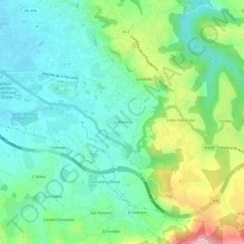
Naam: Topografische kaart La Pontica, hoogte, reliëf.
Locatie: La Pontica, Gijón, Asturias, 33394, España (43.49896 -5.62135 43.53896 -5.58135)
Gemiddelde hoogte: 84 m
Minimale hoogte: 6 m
Maximale hoogte: 277 m
Doe een donatie
Rust jezelf uit voor je volgende avontuur:
Als Amazon-partner verdient deze site een commissie op in aanmerking komende aankopen, zonder extra kosten voor jou.
Andere topografische kaarten
Klik op een kaart om zijn topografie, zijn hoogte en zijn reliëf te bekijken.
Doe een donatie
Rust jezelf uit voor je volgende avontuur:
Als Amazon-partner verdient deze site een commissie op in aanmerking komende aankopen, zonder extra kosten voor jou.
Huerces
Limita al sur con Siero, sirviendo de divisoria el pico de San Martín, de 519 metros de altitud. Hasta los años 1990 era una área muy poco poblada que vivía básicamente de la agricultura y la cercana mina de La Camocha. Desde la última década del siglo XX pasó a ser una zona residencial de Gijón…
Gemiddelde hoogte: 203 m