
Topografische kaart Honey Grove
Interactieve kaart
Klik op de kaart om de hoogte weer te geven.
Over deze kaart
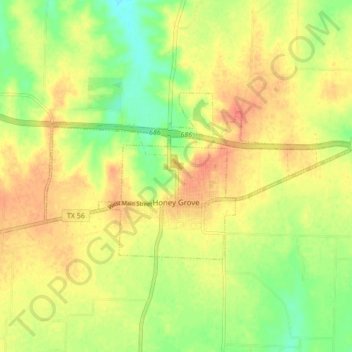
Naam: Topografische kaart Honey Grove, hoogte, reliëf.
Locatie: Honey Grove, Fannin County, Texas, 75446, United States (33.57186 -95.94192 33.60558 -95.85660)
Gemiddelde hoogte: 195 m
Minimale hoogte: 169 m
Maximale hoogte: 215 m
Honey Grove is in central North Texas, in eastern Fannin County, 16 miles (26 km) east of Bonham, the county seat, 39 miles (63 km) north of Greenville, 42 miles (68 km) east of Sherman, and 90 miles (140 km) northeast of the central business district of Dallas. Honey Grove was developed on flat to gently rolling terrain with scattered trees. The city is at an elevation ranging from about 580 to 690 feet (180 to 210 m) above sea level. U.S. Highway 82 and State Highway 56 traverse the city from east to west, and State Roads 34, 100, and 824 run north and south. Bonham is the closest major economic center. Its climate produces an annual average daily maximum temperature of 75.1 °F, and an average annual rainfall is 43.99 inches (1,117 mm). It is also a part of the Texoma region.
Andere topografische kaarten
Klik op een kaart om zijn topografie, zijn hoogte en zijn reliëf te bekijken.
Lamasco
United States > Texas > Fannin County
Lamasco, Fannin County, Texas, United States
Gemiddelde hoogte: 178 m
Dodd City
United States > Texas > Fannin County
Dodd City, Fannin County, Texas, 75438, United States
Gemiddelde hoogte: 199 m
Silver City
United States > Texas > Fannin County
Silver City, Fannin County, Texas, United States
Gemiddelde hoogte: 183 m
Ivanhoe
United States > Texas > Fannin County
Ivanhoe, Fannin County, Texas, 75447, United States
Gemiddelde hoogte: 184 m
Burnett
United States > Texas > Fannin County
Burnett, Fannin County, Texas, 75492, United States
Gemiddelde hoogte: 196 m
Ely
United States > Texas > Fannin County
Ely, Fannin County, Texas, United States
Gemiddelde hoogte: 219 m
Flag Springs
United States > Texas > Fannin County
Flag Springs, Fannin County, Texas, 75492, United States
Gemiddelde hoogte: 197 m
Bonham
United States > Texas > Fannin County
Bonham, Fannin County, Texas, 75418, United States
Gemiddelde hoogte: 184 m
Savoy
United States > Texas > Fannin County
Savoy, Fannin County, Texas, United States
Gemiddelde hoogte: 204 m
Bonham
United States > Texas > Fannin County > Bonham > Bonham
Bonham, Fannin County, Texas, 75418, United States
Gemiddelde hoogte: 184 m
Leonard
United States > Texas > Fannin County
Leonard, Fannin County, Texas, 75452, United States
Gemiddelde hoogte: 210 m
Bailey
United States > Texas > Fannin County > Bailey
Bailey, Fannin County, Texas, United States
Gemiddelde hoogte: 218 m
Allens Chapel
United States > Texas > Fannin County > Allens Chapel
Allens Chapel, Fannin County, Texas, United States
Gemiddelde hoogte: 176 m
Telephone
United States > Texas > Fannin County
Telephone, Fannin County, Texas, 75488, United States
Gemiddelde hoogte: 172 m
Ladonia
United States > Texas > Fannin County
Ladonia, Fannin County, Texas, 75449, United States
Gemiddelde hoogte: 178 m
Ravenna
United States > Texas > Fannin County
Ravenna, Fannin County, Texas, United States
Gemiddelde hoogte: 179 m
Gober
United States > Texas > Fannin County
Gober, Fannin County, Texas, 75443, United States
Gemiddelde hoogte: 199 m