
Topografische kaart Qingyang
Interactieve kaart
Klik op de kaart om de hoogte weer te geven.
Qingyang
Qingyang is the easternmost prefecture-level division of Gansu and is thus sometimes referred to as "Longdong" (陇东). It forms an administrative peninsula, as it is surrounded, on all sides but the south, by Shaanxi and Ningxia. It is in the lower middle part of the Yellow River on the loess plateau and is within the eastern Gansu basin. Elevation ranges from 885 to 2082 meters above sea-level. There are 5 major rivers in Qingyang including the Malian (马莲河), Pu (蒲河), Hong (洪河), Xilang (四郎河), and Hulu or "Gourd" (葫芦河). Their combined annual flow is more than 800 million cubic meters. Bordering prefecture-level cities are.
Over deze kaart
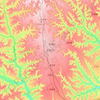
Naam: Topografische kaart Qingyang, hoogte, reliëf.
Locatie: Qingyang, Xifeng District, Qingyang, Gansu, China (35.55061 107.47843 35.87061 107.79843)
Gemiddelde hoogte: 1.268 m
Minimale hoogte: 1.010 m
Maximale hoogte: 1.456 m