
Topografische kaart Inks Lake State Park
Interactieve kaart
Klik op de kaart om de hoogte weer te geven.
Over deze kaart
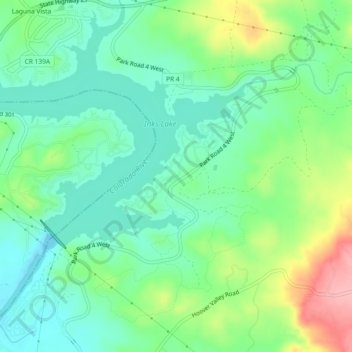
Naam: Topografische kaart Inks Lake State Park, hoogte, reliëf.
Gemiddelde hoogte: 294 m
Minimale hoogte: 253 m
Maximale hoogte: 383 m
Conservation Pool Elevation usually stays around 888.22 ft. msl; however, this lake does fluctuate about 1 foot annually. Inks lake water clarity can be seen as clear to slightly stained mostly throughout the year. It tends to have higher turbidity during the rainy season due to excessive amounts of runoff.