
Topografische kaart Padul
Interactieve kaart
Klik op de kaart om de hoogte weer te geven.
Over deze kaart
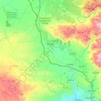
Naam: Topografische kaart Padul, hoogte, reliëf.
Gemiddelde hoogte: 964 m
Minimale hoogte: 508 m
Maximale hoogte: 1.754 m
El Padul is a municipality of south-eastern Spain, in the province of Granada, within the comarca of el Valle de Lecrín. The population on 2008 was 8.440 inhabitants. This town is situated 13 km at the south of the city of Granada. Its altitude is 744 meters above the sea level.
Andere topografische kaarten
Klik op een kaart om zijn topografie, zijn hoogte en zijn reliëf te bekijken.
Restábal
Spain > Andalusia > Comarca del Valle de Lecrín > El Valle
Restábal, El Valle, Comarca del Valle de Lecrín, Granada, Andalusia, 18658, Spain
Gemiddelde hoogte: 636 m