
Doe een donatie
Rust jezelf uit voor je volgende avontuur:
Als Amazon-partner verdient deze site een commissie op in aanmerking komende aankopen, zonder extra kosten voor jou.
Topografische kaart Decatur
Klik op de kaart om de hoogte weer te geven.
Doe een donatie
Rust jezelf uit voor je volgende avontuur:
Als Amazon-partner verdient deze site een commissie op in aanmerking komende aankopen, zonder extra kosten voor jou.
Decatur
According to the United States Census Bureau, the city has a total area of 8.5 square miles (22 km2), all land. The highest point of elevation in the county is the courthouse site. As with ancient hill towns in Europe, the frontier settlement was developed on high ground for defensive purposes, so European settlers could see and ward off attacks or raids, in this case by Native Americans.
Doe een donatie
Rust jezelf uit voor je volgende avontuur:
Als Amazon-partner verdient deze site een commissie op in aanmerking komende aankopen, zonder extra kosten voor jou.
Over deze kaart
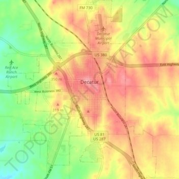
Naam: Topografische kaart Decatur, hoogte, reliëf.
Locatie: Decatur, Wise County, Texas, 76234, United States (33.19772 -97.62301 33.26524 -97.55589)
Gemiddelde hoogte: 297 m
Minimale hoogte: 245 m
Maximale hoogte: 340 m
Doe een donatie
Rust jezelf uit voor je volgende avontuur:
Als Amazon-partner verdient deze site een commissie op in aanmerking komende aankopen, zonder extra kosten voor jou.