
Topografische kaart Coldstream
Interactieve kaart
Klik op de kaart om de hoogte weer te geven.
Over deze kaart
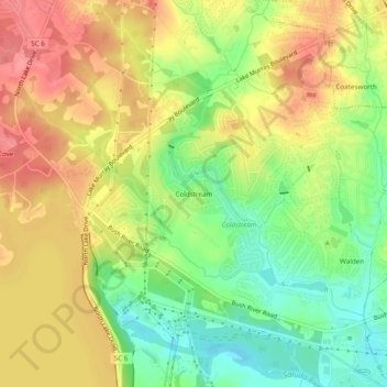
Naam: Topografische kaart Coldstream, hoogte, reliëf.
Gemiddelde hoogte: 94 m
Minimale hoogte: 50 m
Maximale hoogte: 134 m
Andere topografische kaarten
Klik op een kaart om zijn topografie, zijn hoogte en zijn reliëf te bekijken.
Younginer Pond
United States > South Carolina > Lexington County
Younginer Pond, Lexington County, South Carolina, United States
Gemiddelde hoogte: 123 m
Irmo
United States > South Carolina > Lexington County
Irmo, Lexington County, South Carolina, 29212, United States
Gemiddelde hoogte: 94 m
Leesville
United States > South Carolina > Lexington County > Batesburg-Leesville > Leesville
Leesville, Batesburg-Leesville, Lexington County, South Carolina, 29060, United States
Gemiddelde hoogte: 190 m
Cayce
United States > South Carolina > Lexington County
Cayce, Lexington County, South Carolina, 29033, United States
Gemiddelde hoogte: 64 m