
Topografische kaart Saint Clair Shores
Interactieve kaart
Klik op de kaart om de hoogte weer te geven.
Over deze kaart
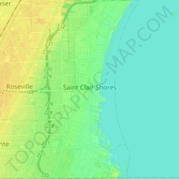
Naam: Topografische kaart Saint Clair Shores, hoogte, reliëf.
Locatie: Saint Clair Shores, Macomb County, Michigan, United States (42.45063 -82.92860 42.54092 -82.85514)
Gemiddelde hoogte: 179 m
Minimale hoogte: 171 m
Maximale hoogte: 192 m
Andere topografische kaarten
Klik op een kaart om zijn topografie, zijn hoogte en zijn reliëf te bekijken.
Armada
United States > Michigan > Macomb County
Armada, Macomb County, Michigan, United States
Gemiddelde hoogte: 228 m
Van Dyke
United States > Michigan > Macomb County > Warren
Van Dyke, Warren, Macomb County, Michigan, 48015, United States
Gemiddelde hoogte: 192 m
Sterling Heights
United States > Michigan > Macomb County
Sterling Heights, Macomb County, Michigan, United States
Gemiddelde hoogte: 191 m
Center Line
United States > Michigan > Macomb County
Center Line, Macomb County, Michigan, 48015, United States
Gemiddelde hoogte: 192 m
Harrison Charter Township
United States > Michigan > Macomb County
Harrison Charter Township, Macomb County, Michigan, United States
Gemiddelde hoogte: 177 m
Shelby Charter Township
United States > Michigan > Macomb County
Shelby Charter Township, Macomb County, Michigan, United States
Gemiddelde hoogte: 205 m
Washington Charter Township
United States > Michigan > Macomb County
Washington Charter Township, Macomb County, Michigan, 48095, United States
Gemiddelde hoogte: 240 m
Sterling Heights
United States > Michigan > Macomb County > Sterling Heights > Sterling Heights
Sterling Heights, Macomb County, Michigan, 48313-4615, United States
Gemiddelde hoogte: 205 m
Macomb Township
United States > Michigan > Macomb County
Macomb Township, Macomb County, Michigan, United States
Gemiddelde hoogte: 189 m
Shelby Charter Township
United States > Michigan > Macomb County > Shelby Charter Township
Shelby Charter Township, Macomb County, Michigan, 48094, United States
Gemiddelde hoogte: 205 m