
Topografische kaart Clinton
Interactieve kaart
Klik op de kaart om de hoogte weer te geven.
Over deze kaart
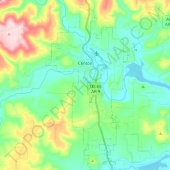
Naam: Topografische kaart Clinton, hoogte, reliëf.
Locatie: Clinton, Van Buren County, Arkansas, 72031, United States (35.52157 -92.49205 35.63269 -92.41459)
Gemiddelde hoogte: 230 m
Minimale hoogte: 138 m
Maximale hoogte: 469 m
Andere topografische kaarten
Klik op een kaart om zijn topografie, zijn hoogte en zijn reliëf te bekijken.
Scotland
United States > Arkansas > Van Buren County
Scotland, Van Buren County, Arkansas, 72141, United States
Gemiddelde hoogte: 242 m
Shirley
United States > Arkansas > Van Buren County
Shirley, Van Buren County, Arkansas, 72153, United States
Gemiddelde hoogte: 205 m
Van Buren County
United States > Arkansas > Van Buren County
Van Buren County, Arkansas, United States
Gemiddelde hoogte: 296 m
Fairfield Bay
United States > Arkansas > Van Buren County > Fairfield Bay
Fairfield Bay, Van Buren County, Arkansas, 72088, United States
Gemiddelde hoogte: 230 m
Fairfield Bay
United States > Arkansas > Van Buren County > Fairfield Bay > Fairfield Bay
Fairfield Bay, Van Buren County, Arkansas, 72088, United States
Gemiddelde hoogte: 225 m