
Topografische kaart Douglas County
Interactieve kaart
Klik op de kaart om de hoogte weer te geven.
Douglas County
According to the U.S. Census Bureau, the county has an area of 738 square miles (1,910 km2), of which 710 square miles (1,800 km2) is land and 28 square miles (73 km2) (3.8%) is water. It is the second-smallest county in Nevada by area. The highest point is East Peak at 9,593 ft (2,924 m), while the most topographically prominent mountain is Mount Siegel.
Over deze kaart
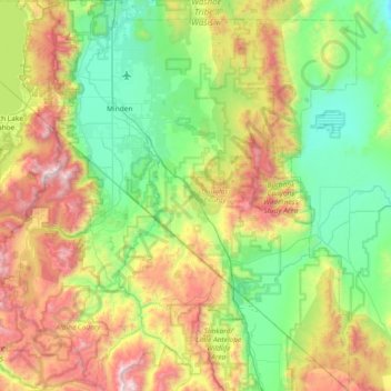
Naam: Topografische kaart Douglas County, hoogte, reliëf.
Locatie: Douglas County, Nevada, United States of America (38.53617 -120.00343 39.11401 -119.31548)
Gemiddelde hoogte: 1.940 m
Minimale hoogte: 1.345 m
Maximale hoogte: 3.308 m