
Topografische kaart Red Rock
Interactieve kaart
Klik op de kaart om de hoogte weer te geven.
Over deze kaart
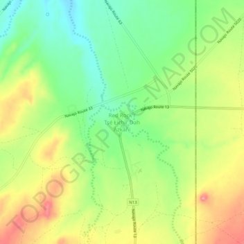
Naam: Topografische kaart Red Rock, hoogte, reliëf.
Gemiddelde hoogte: 1.780 m
Minimale hoogte: 1.726 m
Maximale hoogte: 1.847 m
Andere topografische kaarten
Klik op een kaart om zijn topografie, zijn hoogte en zijn reliëf te bekijken.
Sawmill
United States > Arizona > Apache County
Sawmill, Fort Defiance Agency, Apache County, Arizona, 86549, United States
Gemiddelde hoogte: 2.354 m
St. Michaels
United States > Arizona > Apache County
St. Michaels, Fort Defiance Agency, Apache County, Arizona, 86511, United States
Gemiddelde hoogte: 2.066 m
Concho
United States > Arizona > Apache County > Concho
Concho, Apache County, Arizona, 85914, United States
Gemiddelde hoogte: 1.844 m
Canyon de Chelly National Monument
United States > Arizona > Apache County
Canyon de Chelly National Monument, Chinle Agency, Apache County, Arizona, 87503, United States
Gemiddelde hoogte: 1.770 m
Eagle Crag
United States > Arizona > Apache County
Eagle Crag, Apache County, Arizona, United States
Gemiddelde hoogte: 1.970 m
South Mountain
United States > Arizona > Apache County > Alpine
South Mountain, Alpine, Apache County, Arizona, 75920, United States
Gemiddelde hoogte: 2.716 m
Petrified Forest National Park
United States > Arizona > Apache County
Petrified Forest National Park, Apache County, Arizona, 86028, United States
Gemiddelde hoogte: 1.722 m
Teec Nos Pos
United States > Arizona > Apache County
Teec Nos Pos, Shiprock Agency, Apache County, Arizona, United States
Gemiddelde hoogte: 1.620 m